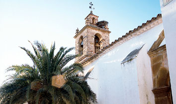


Entered via a winding and descending road, Espiel, as white as a bride, climbs the rocky hill via steep. Entered via a winding and descending road, Espiel, as white as a bride, climbs the rocky hill via steep, crooked streets lined with pavements. Arrises create a play of light and shade on the whitewashed walls of the village. The stone belfry of the parish church provides a nest site for storks, which, rather than migrating, have remained to take advantage of the warm and welcoming local landscape.
- The village is located in the Valle del Guadiato [Guadiato Valley], along the N-432.
- Distance from Córdoba: 50 km.
- Altitude: 547 m.
- Surface area: 441.4 km2.·
- Population: 2422.
- Term used to designate inhabitants: Espeleños
- Region: Valle del Guadiato.
At the beginning of the 13th century a fortified settlement existed on the Cerro del Castillo [a hill], which was ceded to Córdoba in 1237 by Ferdinand III and which, in all likelihood, was deserted in the following century. This settlement represents the precedent of the current village, which appears to have arisen at the end of the 15th century, as a dependency of Belmez. Later, it became a hamlet under the jurisdiction of Villanueva del Rey, up until the middle of the 16th century when it achieved administrative independence under the name of Bodonal, which was subsequently changed to Espiel. The village developed considerably as a result of the relatively recent period of growth within the mining industry.